(Foto del Documento Competo)
(Photo of the Complete Document)
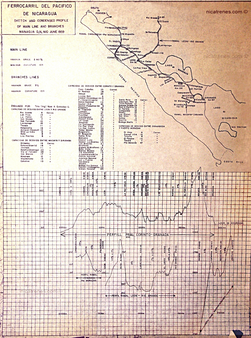
Dibujo y Perfil Condensa de la Línea Principal y Ramales.
/
Documento Oficial del:
“Ferrocarril del Pacifico de Nicaragua”
Dibujados Originales por:
Tnte (Ing) Noel A. González G.
Fecha: Junio, 1959.
/
Este Documento Incluye Cuatro Secciones;
- Un mapa del sistema entero del "Ferrocarril del Pacifico de Nicaragua" como existía en junio de 1959.
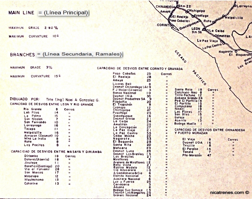
- Una lista de todos los desvíos del ferrocarril, indicando el número total de vagones cada desvío es capaz de contener.
- Este documento organiza los desvíos del ferrocarril en cuatro grupos. Ordenados de la siguiente manera;
- Línea - Ramal; (León - Rio Grande),
- Línea - Ramal; (Masaya - Diriamba),
- Línea Principal; (Corinto to Granada),
- Línea - Ramal; (Chinandega - Puerto Morazán).
- El Grado Máximo de la Línea Principal y Ramales.
- Un Gráfico Mostrando la Altitud (sobre el nivel del mar) de la Línea Principal del ferrocarril y de cada uno de los tres ramales:
- También es de gran importancia que; Cada desvío del ferrocarril es identificado por el nombre de la localidad o de la empresa al cual correspondían.
Nicatrenes da la gracias y está muy agradecido, al Señor Eduardo Pérez-Valle h., por una copia de este documento.
El Señor Eduardo Pérez-Valle h. es un historiador reconocido de Nicaragua.
"Sketch and Condensed Profile of the Main Line and Branches”
/
This is an Official Document of the:
“Ferrocarril del Pacifico de Nicaragua”
Original Drawings by:
Tnte (Ing) Noel A. González G.
(Tnte = military Officer) (Ing = Engineer)
Date: June, 1959.
/
This Document Contains Four Sections;
- A Map of the Entire Railroad System of the “Ferrocarril del Pacifico de Nicaragua”, as it existed in June 1959.
- A list of all the railroad-siding, indicating the number of railway cars each sidings can accommodate.
- This document organizes the railroad sidings into four groups; In the following order;
- Branch-Line; (León - Rio Grande),
- Branch-Line; (Masaya - Diriamba),
- Main - Line; (Corinto to Granada),
- Branch-Line; (Chinandega - Puerto Morazán).
- Maximum Grade and Maximum Curvature for Railroad.
- A Graph Showing the Elevation (height above sea level) for the Main Line and for each of the three Branch Lines:
- This document is also of great significance because the railroad sidings are named by the locality or business they correspond to.
Nicatrens greatly appreciates and gives thanks to Mr. Eduardo Pérez-Valle h. for a copy of this document.
Mr. Eduardo Pérez-Valle h. is a well recognized historian from Nicaraguan.
/
El mapa es de gran relevancia ya que exhibe la mayor parte de las estaciones y Ramales, para todo el sistema ferroviario del "ferrocarril del Pacifico de Nicaragua".
/
Nota: Para enfocar nuestra atención en el mapa, la mapa ha sido fotográficamente retocado y presentado aquí separado del documento original.
/
This Map is of great significant because it displays most of the stations for the entire railroad system of the “Ferrocarril del Pacifico de Nicaragua”.
/
Note: To focus our attention to the map, it has been photographically retouched and presented separated from the original document.
/
Fecha: Junio del año 1959.
/
Este documento organiza los desvíos del ferrocarril en cuatro grupos. Ordenados de la siguiente manera;
- Línea - Ramal; (León - Rio Grande),
- Línea - Ramal; (Masaya - Diriamba),
- Línea Principal; (Corinto a Granada),
- Línea - Ramal; (Chinandega - Puerto Morazán).
3) Grado Máximo Y Curvatura Máxima de las Líneas Ferroviaria;
Línea Principal:
- Grado Máximo: 2.80%
- Curvatura Máxima: 10°
- Grado Máximo: 3%
- Curvatura Máxima: 15°
Nota 1): Este parte del documento es muy significativo, porque los desvíos son llamados por el lugar o negocio a que corresponden, para el entero sistema del “Ferrocarril del Pacifico de Nicaragua”.
Nota 2): Para enfocar nuestra atención en la lista de los desvíos, esta lista ha sido fotográficamente retocado y presentado aquí separado del documento original.
/
Date: June, 1959.
/
This document organizes the railroad sidings into four groups; In the following order;
- Branch-Line; (León - Rio Grande),
- Branch-Line; (Masaya - Diriamba),
- Main - Line; (Corinto to Granada),
- Branch-Line; (Chinandega - Puerto Morazán).
3) Maximum Grade and Maximum Curvature for Railroad;
Main Line:
- Maximum Grade: 2.80%
- Maximum Curvature: 10°
- Maximum Grade: 3%
- Maximum Curvature: 15°
Note 1): This part of the document is of great significant because because the sidings are named by the locality or business they correspond to, for the entire railroad system of the “Ferrocarril del Pacifico de Nicaragua”.
Note 2): To focus our attention to the railroad siding's list, this list has been photographically retouched and presented here separated from the original document.

para el “Ferrocarril del Pacifico de Nicaragua,” en 1959
/
Para distinguir claramente una caja con un número ha sido dibujada alrededor de cada sección del ferrocarril, que son representados en este documento.
Las regiones están numeradas de la siguiente manera;
- A) Línea Principal; {Corinto-Granada}
- Las Tres Líneas Ramales;
- • B1) {Chinandega - Puerto Morazán}
• B2) {León - Rio Grande}
• B3) {Masaya - Diriamba}
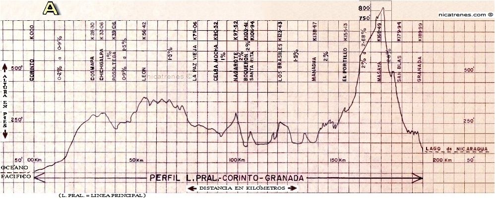
Este Gráfico Contiene;
- 1) Principales Estaciones Ferroviarias, organizados por su distancia desde la izquierda (Corinto) a derecho (Granada).
- 2) Distancia in kilometers.
- 3) La Inclinación del Grado.
Las líneas de gráfico nos dan dos medidas; la Elevación (en pies encima del nivel del mar) y los Distancias en kilómetros.
- Elevación; En este gráfico se nos muestra una altitud para el punto más bajo (de cero pies), en la ciudad de Corinto.
- El punto más alto de la línea principal es entre 800 y 850 pies sobre el nivel del mar, situado a pocos kilómetros al sur de Masaya, entre Masaya y Granada.
- Distancia; Este gráfico mide todas las distancias desde la ciudad de Corinto, en kilómetros.
Nota: Para enfocar nuestra atención en el Gráfico, ha sido fotográficamente retocado y es presentado aquí separado del documento original.
/
To clearly distinguish the railroad’s sections, represented in this document, a box with a number has been drawn around each of the railroad sections.
The regions are numbered as following order;
- A) Main Line; {Corinto-Granada}
- The Three Branch-Lines;
- • B1) {Chinandega - Puerto Morazán}
• B2) {León - Rio Grande}
• B3) {Masaya - Diriamba}
This Graph Contains;
- 1) Principle Railroad Stations, organized by their distance from the city of Corinto).
- 2) Distances in kilometers.
- 3) The Angle of the Grade.
The lines of graph give us two measurements; the Elevation (in feet above sea level) and the Distances are measured in kilometers.
- Elevation; In this graph we are shown an altitude for the lowest point (of Zero feet), at The City of Corinto.
- The highest point in the graph is between 800 and 850 feet above sea level, located a few kilometers south of Masaya, between Masaya to Granada.
- Distance; This graph measures all the distances from The City of Corinto, in kilometers.
Note: To focus our attention to the Graph, it has been photographically retouched, it is presented separated from the original document.
Corinto a Granada
Corinto to Granada
/
Este gráfico contiene;
- 1) Principales Estaciones Ferroviarias, organizados por su distancia desde la izquierda (Corinto) a derecho (Granada).
- 2) Distancia in kilometers.
- 3) La Inclinación del Grado.
Las líneas de gráfico nos dan dos medidas; la Elevación (en pies encima del nivel del mar) y la Distancia (comenzando los kilómetros medidos de la ciudad de Corinto).
- Elevación; En este gráfico se nos muestra una altitud para el punto más bajo (de cero pies), en la ciudad de Corinto.
- El punto más alto de la línea principal es entre 800 y 850 pies sobre el nivel del mar, situado a pocos kilómetros al sur de Masaya, entre Masaya y Granada.
- Distancia; Este gráfico mide todas las distancias desde la ciudad de Corinto, en kilómetros.
/
This Graph Contains;
- 1) Principle Railroad Stations, organized by their distance from left (Corinto) to right (Granada).
- 2) Distances in kilometers.
- 3) The Angle of the Grade.
The lines of graph give us two measurements; the Elevation (in feet above sea level) and the Distance traveled (starting the measured kilometers from the city of Corinto).
- Elevation; In this graph we are shown an altitude for the lowest point (of Zero feet), at The City of Corinto.
- The highest point in the graph is between 800 and 850 feet above sea level, located a few kilometers south of Masaya, between Masaya to Granada.
- Distance; This graph measures all the distances from The City of Corinto, in kilometers.
- /
- Note: To focus our attention to the Graph of the Main Line, it has been photographically retouched, it is presented here, separated from the original document.
En el orden siguiente;
(*Altitud es estimada por su posición en el gráfico.)
=======
OCÉANO PACIFICO (Yo añadí la ubicación del océano)
**Puerto Corinto -0.5 Km (Yo añadí esta distancia)
CORINTO 0.00 Km + Alt. 0.0 pies
(Corinto es designado como; el cero "0" kilómetro)
0.2 % to 0.9% Grado
COSMAPA = 28.30 Km + Alt @ 275 pies*
CHICHGALPA 33.06 Km + Alt. @ 300 pies*
1% Grado
POSOLTEGA = 39.06 Km + Alt. @ 220 pies*
0.9 to 1.5% Grado
LEÓN = 56.42 Km + Alt. @ 375 pies*
1.5% Grado
LA PAZ VIEJA = 79.06 Km + Alt. @ 240 pies*
CELBA MOCHA = 90.52 Km + Alt. @200 pies*
1% Grado
NAGAROTE = 97.52 Km + Alt. @ 275 pies*
2% Grado
BOQUERON =103.41Km + Alt. @ 150-175 pies*
2% Grado
SANTA RITA = 106.94 Km + Alt. @ 150-175 pies*
LOS BRASILES = 123.43 Km + Alt. @ 200 pies*
1.5% Grado
MANAGUA = 138.47 Km + Alt. @ 150 pies*
2% Grado
EL PORTILLO = 155.13 Km + Alt. @ 375 pies*
2% to 2.68% Grado
MASAYA = 168.49 Km + Alt. @ 790 pies*
SAN BLAS = 179.94 Km + Alt. @ 300 pies*
2.8% Grado
GRANADA = 189.99 Km + Alt. @ 125 pies*
LAGO DE NICARAGUA
/
In the following order;
(*Altitude is estimated by the position on the graph.)
=======
OCÉANO PACIFICO (I added the location of the ocean)
**Puerto Corinto -0.5 Km (I added this distance)
CORINTO 0.00 Km + Alt. 0.0 ft
(Corinto is designated as the zero “0” kilometer)
0.2 % to 0.9% Grade
COSMAPA = 28.30 Km + Alt @ 275 ft*
CHICHGALPA 33.06 Km + Alt. @ 300 ft*
1% Grade
POSOLTEGA = 39.06 Km + Alt. @ 220 ft*
0.9 to 1.5% Grade
LEÓN = 56.42 Km + Alt. @ 375 ft*
1.5% Grade
LA PAZ VIEJA = 79.06 Km + Alt. @ 240 ft*
CELBA MOCHA = 90.52 Km + Alt. @200 ft*
1% Grade
NAGAROTE = 97.52 Km + Alt. @ 275 ft*
2% Grade
BOQUERON =103.41Km + Alt. @ 150-175 ft*
2% Grade
SANTA RITA = 106.94 Km + Alt. @ 150-175 ft*
LOS BRASILES = 123.43 Km + Alt. @ 200 ft*
1.5% Grade
MANAGUA = 138.47 Km + Alt. @ 150 ft*
2% Grade
EL PORTILLO = 155.13 Km + Alt. @ 375 ft*
2% to 2.68% Grade
MASAYA = 168.49 Km + Alt. @ 790 ft*
SAN BLAS = 179.94 Km + Alt. @ 300 ft*
2.8% Grade
GRANADA = 189.99 Km + Alt. @ 125 ft*
LAGO DE NICARAGUA
/
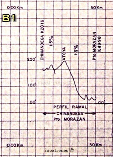
Chinandega to Puerto Morazán
Chinandega to Puerto Morazán
/
Este gráfico mide todas las distancias desde la ciudad de Corinto, en kilómetros.
En el orden siguiente;
- (*Altitud es estimada por su posición en el gráfico.)
1.5% Grado
ATOYA = (?) Km + Alt. @ 250 pies*
1.5% Grado
PUERTO MORAZÁN = 49.98 Km + Alt. @25 pies*
/
Nota: Para enfocar nuestra atención en el Gráfico de la Línea Ramale (Chinandega - Puerto Morazán), ha sido fotográficamente retocado y es presentado aquí separado del documento original.
This graph measures all the distances from The City of Corinto, in kilometers.
In the following order;
- (*Altitude is estimated by the position on the graph.)
1.5% Grade
ATOYA = (?) Km + Alt. @ 250 ft*
1.5% Grade
PUERTO MORAZÁN = 49.98 Km + Alt. @25 ft*
/
Note: To focus our attention to the Graph of the Branch Line (Chinandega - Puerto Morazán), it has been photographically retouched, it is presented here, separated from the original document.
León a Rio Grande
León to Rio Grande
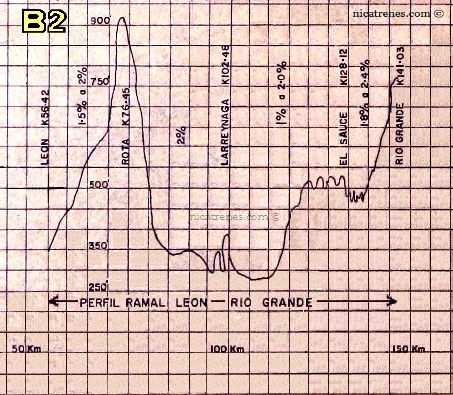
Este gráfico mide todas las distancias desde la ciudad de Corinto, en kilómetros.
En el orden siguiente;
- (*Altitud es estimada por su posición en el gráfico.)
1.5% to 2% Grado
ROTA = 76.45 Km + Alt. @ 850 pies*
2% Grado
LARREYNAGA = 102.48 Km + Alt. @ 325 (or 375) pies*
1% to 2.0% Grado
EL SAUCE = 128.12 Km + Alt. @ 475 pies*
1.8% to 2.4% Grado
RIO GRANDE = 141.03 Km + Alt. @ 775 pies*
/
Nota: Para enfocar nuestra atención en el Gráfico de la Línea Ramale (León a Rio Grande), ha sido fotográficamente retocado y es presentado aquí separado del documento original.
This graph measures all the distances from The City of Corinto, in kilometers.
In the following order;
- (*Altitude is estimated by the position on the graph.)
1.5% to 2% Grade
ROTA = 76.45 Km + Alt. @ 850 ft*
2% Grade
LARREYNAGA = 102.48 Km + Alt. @ 325 (or 375) ft*
1% to 2.0% Grade
EL SAUCE = 128.12 Km + Alt. @ 475 ft*
1.8% to 2.4% Grade
RIO GRANDE = 141.03 Km + Alt. @ 775 ft*
/
Note: To focus our attention to the Graph of the Branch Line (León to Rio Grande), it has been photographically retouched, it is presented here, separated from the original document.
Masaya a Diriamba
Masaya to Diriamba
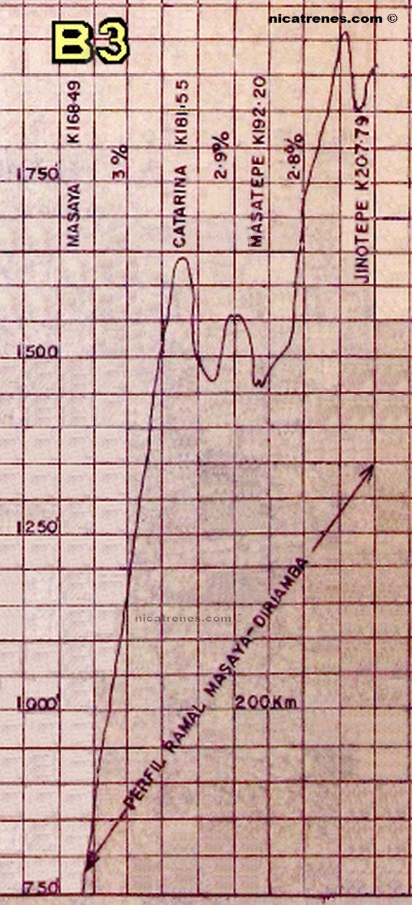
Este gráfico mide todas las distancias desde la ciudad de Corinto, en kilómetros.
En el orden siguiente;
- (*Altitud es estimada por su posición en el gráfico.)
3% Grado
CATARINA = 181.55 Km + Alt. @ 1640 pies*
2.9% Grado
MASATEPE = 192.20 Km + Alt. @ 1475 pies*
2.8% Grado
JINOTEPE = 207.79 Km + Alt. @ 475 pies*
1.8% to 2.4% Grado
DRIAMBA = 215 Km + Alt. @ 1925 pies*
- (Diriamba ha sido calculado, para estar localizado al final de línea en el gráfico.)
/
This graph measures all the distances from The City of Corinto, in kilometers.
/
In the following order;
- (*Altitude is estimated by the position on the graph.)
3% Grade
CATARINA = 181.55 Km + Alt. @ 1640 ft*
2.9% Grade
MASATEPE = 192.20 Km + Alt. @ 1475 ft*
2.8% Grade
JINOTEPE = 207.79 Km + Alt. @ 475 ft*
1.8% to 2.4% Grade
DRIAMBA = 215 Km + Alt. @ 1925 ft*
- (Diriamba has been calculated, as to be located at the end of the line on the graph)