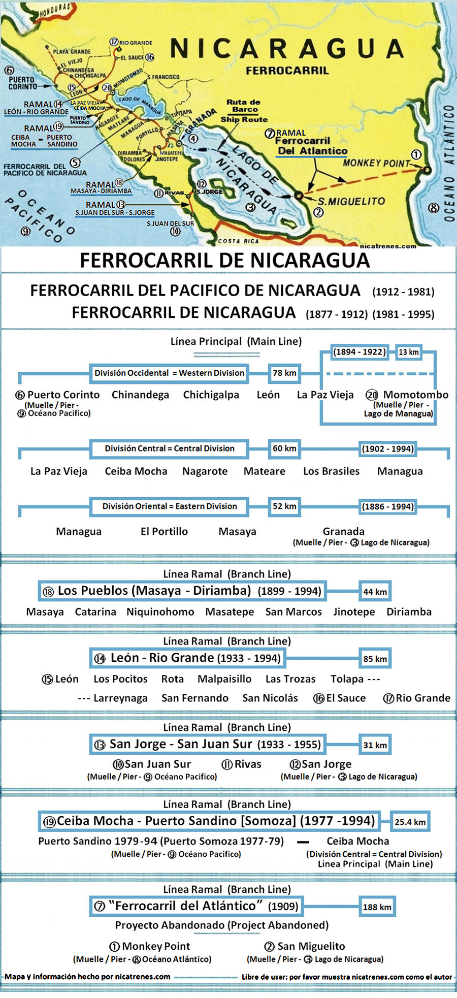
de Nicaragua

F.C.P.N.
de Nicaragua
F.C.N.
| Central America | |||||||||
| Ferrocarril | Nicaragua | Railroad | |||||||
| nicatrenes.com | |||||||||
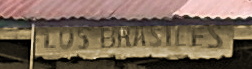
| ESTACIÓN LOS BRASILES | |||||||||
| Ferrocaril del Pacifico de Nicaragua F.C.P.N. | | Ferrocaril de Nicaragua F.C.N. |
| Estación de Ferrocarril "Los Brasiles" | Railroad Station "Los Brasiles" |
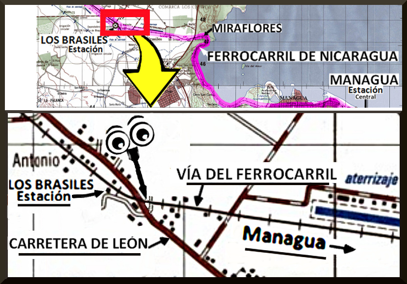
| La Estación de los Brasiles está ubicada a unos 15 kilómetros al oeste de Managua, / En la ruta de la ciudad capital de Managua hacia la ciudad de León. | The los Brasiles Station is located about 15 kilometers west of Managua, / On the route from the capital city of Managua towards the city of Leon. |
 | |
| Estación de Ferrocarril "Los Brasiles" | Railroad Station "Los Brasiles" |
| Nota; En Las Siguientes ilustraciones; Los ojos con la flecha aproximan desde qué ángulo el fotógrafo tomó la foto. | Note; In the Following illustrations; The eyes with the arrow approximates from which angle the the photographer took the photo. |
| Año 2007 | Year 2007 |
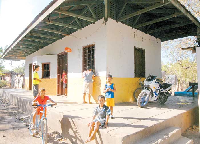  | |
| Estación "Los Brasiles" / Fecha de foto: 2007 (Nota; Las rieles férreas fueron completamente retiradas en 1995 con la terminación del ferrocarril) / Fotógrafo: Orlando Valenzuela / Foto tomada de: La Prensa (periódico) 22 de abril de 2007 La siguiente información es del periódico La Prensa, del 22 abril de 2007; "Doña Juana Somarriba llegó dos años antes que el ferrocarril cerrara operaciones y ahora es su hogar donde instaló una pequeña pulpería." | Train Station "Los Brasiles" / Date of Photo: 2007 (Note; Railroad tracks were completely removed by 1995 with the termination of the railroad) / Photographer; Orlando Valenzuela / Photo taken from: La Prensa (newspaper) April 22, 2007. The following information is from the newspaper La Prensa, April 22, 2007; Mrs. Juana Somarriba arrived at the station two years before the railroad ceased operations and now it is her home where she has installed a small neighborhood grocery shop. |
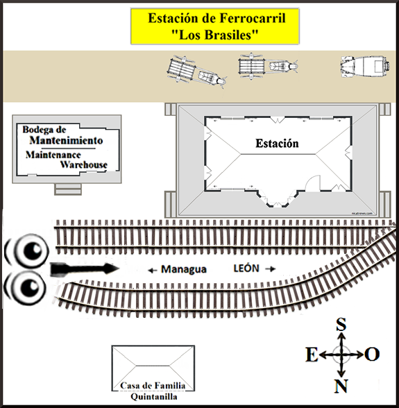
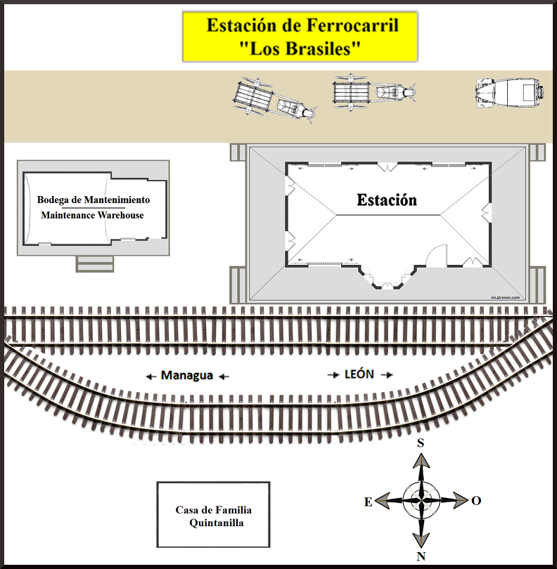
| Nota: En todos los diagramas de la "Estación Los Brasiles"; la calle (para autos y peatones) se ilustra donde antes estaba, en el lado sur de la estación, donde la calle solía estar mientras el ferrocarril estaba en funcionamiento. En la actualidad (en 2016); la calle (para autos y peatones) se encuentra ahora al otro lado de la estación, en el lado norte donde estaban las vías de ferrocarril (al lado de la ventana de boletos). | Note: In all the diagrams of the "Los Brasiles Station"; the road (for cars and pedestrians) is illustrated where it previously was, on the south side of the station, while the railroad was in operation. At present (in 2016) the road (for cars and pedestrians) is now located on the other side of the station, where the railroad tracks used to be, on the North side (the ticket window side). | ||
| Estaciónde Ferrocarril "Los Brasiles" | Railroad Station "Los Brasiles" |
| Año 2008 | Year 2008 |
   | |
| Español | English |
| Estación de Ferrocarril "Los Brasiles" / Fotógrafo; Gerardo Quintanilla Fecha de foto: 2008 (Nota; Las rieles férreas fueron completamente retiradas en 1995 con la terminación del ferrocarril) / La siguiente información ha sido compartida por Gerardo Quintanilla; Mi familia vivia frente a la estacion de "Los Brasiles", la estacion esta a unos 15 kilometros al oeste de Managua. "Los Brasiles" era la tercera estación saliendo de Managua hacia Leon. La primera estación, saliendo de Managua hacia Leon, era "Bella Vista" (que era una estación pequeña, de parada de bandera), la segunda estación era "Mira Flores" y luego la estación "Los Brasiles". (NOTA; En una "estación de parada de bandera"; el tren sólo se detiene en la estación si hay necesidad de parar. (ejemplo = el tren sólo se detiene si; hay una necesidad de que alguien necesita subir o bajar del tren, o enviar o recibir un paquete.) Gerardo Quintanilla continúa; Crecí frente a la estación de tren de "Los Brasiles" y monté en el tren por muchas razones... ¡extraño nuestro tren! En mi niñez, recuerdo que la vida diaria giraba alrededor del tren en Los Brasiles; El tren de las cinco de la mañana procedente de Managua era la hora de levantarnos y el tren de las ocho de la noche, hacia Managua, era la hora de acostarnos. Los periódicos, el correo, y las frutas y verduras (que no se cultivaban localmente) llegaban en los trenes, la producción de leche y granos locales se enviaban a Managua por tren. La economía local dependía del tren mayormente. 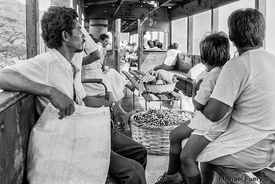 (Esta foto muestra a los comerciantes llevando sus canastas y sacos de comida en tren para vender en el mercado.) (Esta foto fue tomada por "Michael Fuery" en el tren de León a Managua, en el año 1986.) Gerardo Quintanilla continúa con su información; El único teléfono local disponible era el de la estación, y un personaje muy destacado era el jefe de la estación, él y su familia, todos buenos amigos de mi familia, recuerdo con cariño Mateo Vargas, Vladimir Soza, Zenelia Soza (unica mujer que fue jefe de estacion)..etc. / El edificio en esta foto, fotografiado en el año 2008, fue construido a finales de los años 40, probablemente en 48 o 49, yo era un niño en ese momento. Este edificio sustituyó a una antigua estación de madera, que años antes había sido trasladada a este lugar, desde otra ubicación (tomada desde un par de kilómetros de distancia.) Lo que pasó es que en algún momento en el pasado, no sé cuándo, la ruta a "León" desde "Managua" recorrió la "Laguna Asososca" a través de "Batahola," 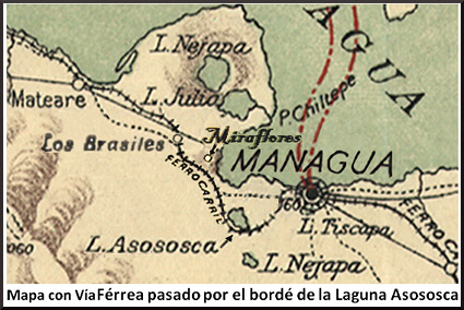 El ferrocarril abrió una ruta mejor, siguiendo de cerca la costa del "Lago de Managua" ("Logo de Xolotlán"), con paradas en "Bella Vista" (una parada de bandera) y la estación de "Miraflores",  Mapa que muestra la ruta ferroviaria desde desde la estación de "Los Brasiles", pasando por la estación de "Miraflores" y siguiendo hacia la ciudad Capital de "Managua," siguiendo de cerca la costa del "Lago de Managua" ("Lago de Xolotlán".) / Antes de que las vías del ferrocarril fueran desviadas en 1933, la antigua estación de "Los Brasiles" estaba situada donde actualmente se encuentra la "Nueva Carretera a León," a un par de kilómetros al este del edificio existente que fue la estación de "Los Brasiles". / nicatrenes agradece y aprecia al Sr. Gerardo Quintanilla; por compartir la fotografía de la estación "Los Brasiles" del año 2008, y su información correspondiente, con nuestra familia del ferrocarril de Nicaragua. | Railroad Station "Los Brasiles" / Photographer; Gerardo Quintanilla Date of photo: 2008 (Note; Railroad tracks were completely removed by 1995 with the termination of the railroad) / The following information was shared by Gerardo Quintanilla; My family lived in front of the “Los Brasiles” train station, the station is 15 kilometers West of the city of Managua. “Los Brasiles” was the third station leaving out of Managua heading for León. The first station, leaving out of Managua heading for León, was “Bella Vista” (which was a small flag stop station), the second station was “Mira Flores” and third the “Los Brasiles” station. (NOTE; At "flag stop station"; the train only stops at the station if there is a need to stop. (example = the train only stops if; there is a necessity for someone whom needs to get on or off the train, or to send or receive a package.) Translations of station names: (“Bella Vista” = Beautiful View) (“Mira Flores” = Flower Look) ("Los Brasiles" = The Brazilians) Gerardo Quintanilla continues; I grew up in front of the "Los Brasiles" train station and I rode on the train for many reasons...I miss our train! In my youth, I remember that daily life in "Los Brasiles" revolved around the train; The train arriving at five in the morning, originating from Managua, was the hour for us to awaken and the train arriving at eight at night, bound for Managua, was the hour for our bedtime. The newspapers, the mail and fruits and vegetables (which were not cultivated locally) arrived in the trains, the local production of milk and grains were shipped to Managua by the trains. The local economy depended primarily on the trains. (This photo shows the merchants taking their baskets and sacks of food by train to sell at the market.) (This photo was taken by "Michael Fuery" on the train from León to Managua, in the year 1986.) Gerardo Quintanilla's continues with his information; The only local telephone available belonged to the railroad station, the station manager was an out-standing individual, he and his family were all good friends of my family, I remember with affection Mateo Vargas, Vladimir Soza, Zenelia Soza (the only woman who was Station Master)...etc. / The building in this photo, photographed in the year 2008, was constructed at the end of the 1940’s probably around 48 or 49, I was a child then. This building replaced an old wooden station, which years before had been moved to this location, from another location (taken from a couple of kilometers away). What happened is that some time in the past, I don't know when, the route to "Leon" from "Managua" went around the "Asososca Lagoon" through "Batahola," 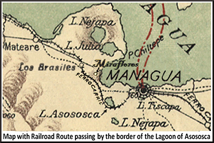 The railroad opened a better route, following close along the coast of "Lake Managua" ("Lake Xolotlán"), with stops at “Bella Vista” (a flag Stop) and “Miraflores” Station, Map showing railway route from "Los Brasiles" station, passing through the "Miraflores" station and on towards the Capital City of "Managua," following close along the coast of "Lake Managua" ("Lake Xolotlán".) / Before the railroad tracks were rerouted in 1933; the old “Los Brasiles” station was located where the "New Highway to Leon" ("Nuevo Carretera a Leon") is presently located, a couple of kilometers east of the existing building which was the station. / nicatrenes thanks and greatly appreciates Mr. Gerardo Quintanilla; for sharing the photograph of the "Los Brasiles" station from the year 2008, and it's corresponding information, with our Nicaragua railroad family. |
| FOTO AÑO 1986 Vendedores de verduras y frutas en el "Ferrocarril de Nicaragua". Ubicación desconocida 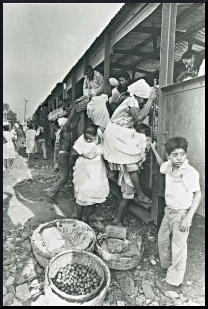 Vegetable and fruit venders on the Ferrocarril de Nicaragua". Location unknown | |
| Bodega de Mantenimiento | Maintenance Warehouse |
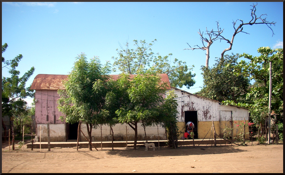  | |
| Bodega de Mantenimiento en "Los Brasiles" Fotógrafo; Gerardo Quintanilla Fecha de foto: 2008 La siguiente información ha sido compartida por Gerardo Quintanilla; Esta es una foto que tomé en 2008 de este antiguo edificio a unos metros al este de la estación de tren. En este edificio antes vivía el jefe de cuadrilla encargado de mantener las vías férreas en buen estado en esa zona. También guardaban todo tipo de materiales para esta tarea. Mi tío Gonzalo Blanco era uno de los jefes de cuadrilla cuando yo era niño, y también recuerdo a un señor de Masaya, que se llamaba Adán González. / nicatrenes agradece y aprecia al Sr. Gerardo Quintanilla; por compartir la fotografía de la estación "Los Brasiles" del año 2008, y su información correspondiente, con nuestra familia del ferrocarril de Nicaragua. | Maintenance Warehouse in "Los Brasiles" Photographer; Gerardo Quintanilla Date of photo: 2008 The following information was shared by Gerardo Quintanilla; This is a picture I took in 2008 of this old building a few yards east of the train station. In this building there used to live the work crew manager in charge of maintaining the tracks in good condition in that area. They kept all kinds of materials there for this task also. My uncle Gonzalo Blanco was one of the crew managers when I was a child, and I also remember a gentleman from Masaya, whose name was Adan Gonzalez. / nicatrenes thanks and greatly appreciates Mr. Gerardo Quintanilla; for sharing the photograph of the "Los Brasiles" station from the year 2008, and it's corresponding information, with our Nicaragua railroad family. |
| Nota; En Las Siguientes ilustraciones; Los ojos con la flecha aproximan desde qué ángulo el fotógrafo tomó la foto. | Note; In the Following illustrations; The eyes with the arrow approximates from which angle the the photographer took the photo. |
| Año 2019 | Year 2019 |
 | |
| La "Estación de Los Brasiles" como se veía en el año 2019 - Mostando el lado de la vía férrea con la ventana de Boletos y el lado Oeste que sólo tiene una ventana. (Foto de Facebook) | "Los Brasiles Station" as it looked in the year 2019 Showing the Track side with the ticket window and the West Side which has only one window. (Photo from Facebook) |
| Año 2016 | Year 2016 |
| Puente ferroviario situado justo después de la salida del tren de la estación "Los Brasiles", en dirección a Managua | Railroad Bridge located just after the train departed from the "Los Brasiles" station, heading towards Managua |
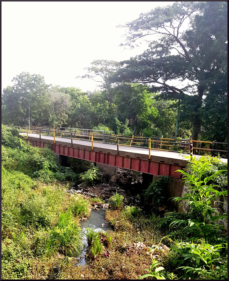  | |
| Puente Ferroviario; Cuando el tren salía de la estación "Los Brasiles", en dirección a Managua, cruzaba este puente ferroviario; / El puente se encuentra justo después de que las vías del tren cruzaran la carretera de León. / Foto tomada en 2016, este puente ha sido reconvertido para el uso de autos y peatones. | Railroad Bridge; When the train departed from the "Los Brasiles" station, heading towards Managua, it would cross this railroad Bridge. / The bridge is located just after the railroad tracks crossed the Leon highway. / Photo was taken in 2016, this bridge has been converted for the use of cars and pedestrians. |
| Si miras donde la parte superior de la capa de cemento se une a la parte metálica del puente; puedes ver donde se habrían colocado las durmientes de madera de las rieles de la vía férrea. | If you look at where the top cement roadbed meets the metal part of the bridge; you can see where the wooden railroad ties would have been placed for the railroad tracks. |
| Ruta Ferroviaria pasado por "Miraflores" | Railroad Route passing through Miraflores |
Mapa; "Los Brasiles" a "Miraflores" a "Managua" Ferrocarril de Nicaragua 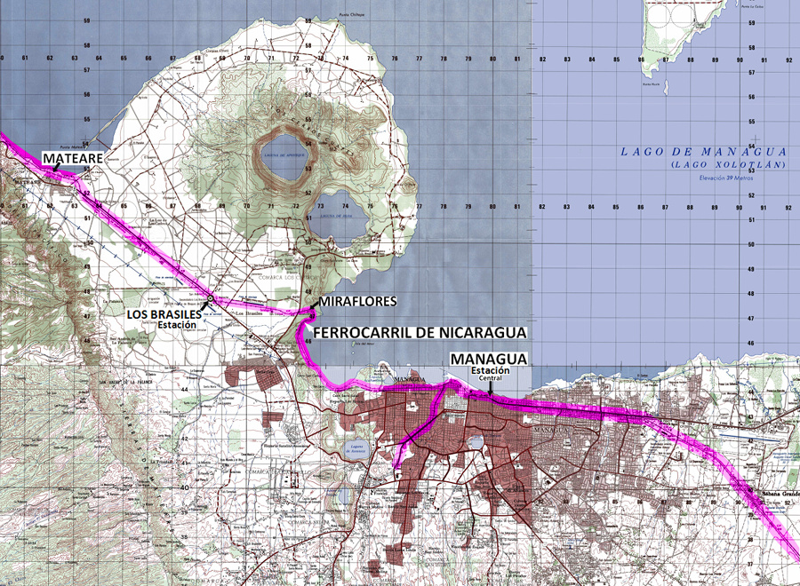 | |
| Ruta Ferroviaria pasado por "Miraflores" a lo largo de las orillas de la costa del "Lago de Managua" Después de que la vía fuera realineada en el año 1933 | Railroad Route passing through Miraflores along the shores of "Lake Managua" After route was realigned in the year 1933 |
| Nota; En el mapa anterior; la flecha marcada con "Ferrocarril de Nicaragua" se aproxima a donde esta ubicada la locomotora No. 28 en la siguiente foto. | Note; In the previous map; the arrow tagged with "Ferrocarril de Nicaragua" approximates where locomotive No. 28 is located in the next photo. |
Locomotora No.28  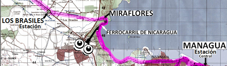 | |
| NOTA: Los ojos con la flecha en este mapa se aproxime desde qué ángulo el fotógrafo tomó la foto, de la locomotora No. 28. | NOTE: The eyes with the arrow in this map approximates from which angle the the photographer took the photo, of locomotive No. 28. |
| Español; Locomotora No. 28, entre las dos estaciones de "Miraflores" y "Bella Vista. Foto de la Locomotora No. 28 copiada de: Locodriver.co .ukRailway _Encyclopedia / La siguiente información ha sido compartida por Gerardo Quintanilla; Esta foto es del tren saliendo de "Miraflores" hacia "Managua" bordeando el lago. La "estación de Miraflores" estaba justo al doblar la curva en la parte superior derecha de esta foto (donde se ve que termina la tierra.) En esta foto la estación "Bella Vista" estaba como a unos 500 metros adelante de esa locomotora numero 28 . "Bella Vista", era una estación pequeña de bandera, y que no siempre se paraba el tren. (NOTA; En una "estación de parada de bandera"; el tren sólo se detiene en la estación si hay necesidad de parar. (ejemplo = el tren sólo se detiene si; hay una necesidad de que alguien necesita subir o bajar del tren, o enviar o recibir un paquete.) / La ruta a León desde "Managua" originalmente recorrió la "Laguna Asososca" a través de "Batahola," pero abrieron una mejor ruta alrededor del "Lago Managua" con paradas en "Bella Vista" y "Miraflores." nicatrenes agradece y aprecia al Sr. Gerardo Quintanilla; por compartir esta información con nuestra familia del ferrocarril de Nicaragua. // ***De una carta al Gerente General (José de la Luz Guerrero) escrito por el Ingeniero de Mantenimiento del F. C. del P. de N. (Fecha 30 de junio de 1932): (Nota: estoa carta ha sido abreviado y simplificado) CONSTRUCCION - Actualmente se está levantando la vía desde el K.109 ("Boquerón") al K.116 ½ ("Mateare") y desde el K128 al K.133 ("Los Brasiles" a "Managua") en la parte que la via bordea el "Lago de Managua." (Se puede encontrar una cita más completa en la sección "El cambio de ruta que causó el traslado de la antigua estación "Los Brasiles" más abajo en esta página web). (información de un documento oficial del ferrocarril en el "Archivo Histórico del "Palacio Nacional de Nicaragua"). / nicatrenes agradece y aprecia al "Archivo Histórico del Palacio Nacional de Nicaragua" por compartir esta información con nuestra familia del ferrocarril de Nicaragua. | English; Locomotive No. 28, between the two railway stations of "Miraflores" and "Bella Vista. Photo of Locomotive No. 28 copied from: Locodriver.co .ukRailway _Encyclopedia / The following information was shared by Gerardo Quintanilla; This photo is of the train leaving Miraflores heading towards "Managua" bordering the shore of "Lake Managua". "Miraflores Station" was just as you turned around the bend at the top right of this photo (where you see the land ends.) In this photo "Bella Vista" station was about 500 meters ahead of locomotive number 28. "Bella Vista," was a small flag station, and the train did not always stop there, (NOTE; At "flag stop station"; the train only stops at the station if there is a need to stop. (example = the train only stops if; there is a necessity for someone whom needs to get on or off the train, or to send or receive a package.) / The route to "Leon" from "Managua" originaly went around the "Asososca Lagoon" through "Batahola," but they opened a better route running along close-to the shore of "Lake Managua" with stops at "Bella Vista" and "Miraflores." nicatrenes thanks and greatly appreciates Mr. Gerardo Quintanilla; for sharing this information with our Nicaragua railroad family. // *** from a letter to the General Manager (José de la Luz Guerrero) written by the Maintenance Engineer of the F. C. del P. de N. (Date July 30, 1934): (Note; this letter has been abridged and simplified) (A more complete qoute can be found farther down this webpage) CONSTRUCTION - The railroad track is currently being built from the Kilometer 109 ("Boquerón") to K.116 ½ ("Mateare") and from Kilometers 128 to 133 ("Los Brasiles" to "Managua") along the part of the route which borders the the shore of "Lake Managua." (A more complete quote can be found in the section "The route change which caused the move of the old Los Brasiles station" farther down this webpage.) (This information from an official railroad document in the the "Historical Archives of the "National Palace of Nicaragua".) / nicatrenes thanks and greatly appreciates the "Historical Archives of the "National Palace of Nicaragua"; for sharing this information with our Nicaragua railroad family. |
| Nota: En todos los diagramas de la "Estación Los Brasiles"; la calle (para autos y peatones) se ilustra donde antes estaba, en el lado sur de la estación, donde la calle solía estar mientras el ferrocarril estaba en funcionamiento. En la actualidad (en 2016); la calle (para autos y peatones) se encuentra ahora al otro lado de la estación, en el lado norte donde estaban las vías de ferrocarril (al lado de la ventana de boletos). | Note: In all the diagrams of the "Los Brasiles Station"; the road (for cars and pedestrians) is illustrated where it previously was, on the south side of the station, while the railroad was in operation. At present (in 2016) the road (for cars and pedestrians) is now located on the other side of the station, where the railroad tracks used to be, on the North side (the ticket window side). | ||
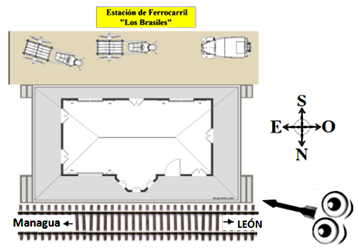
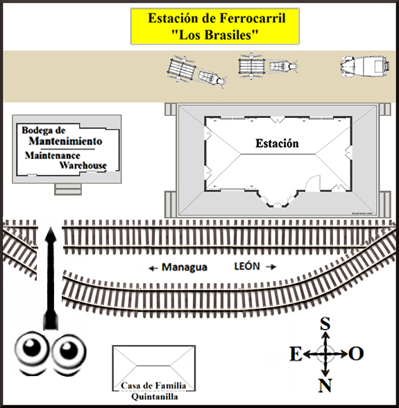
| Diagrama de la Estación de los Brasiles | Diagram of los Brasiles Station |
 | |
|
Esta diagrama es una representación de un dibujo realizado por Gerardo
Quintanilla de la "Estación de Los Brasiles" y del almacén de
mantenimiento. Gerardo Quintanilla vivía frente a la estación. Un documento oficial del ferrocarril de 1959 indicaba que el desvío ferroviario de Los Brasiles tenía capacidad para 25 vagones y desvio desmont (comercial?) para 15 vagones. | This
diagram is a representation of a drawing made by Gerardo Quintanilla of
the Los Brasiles Station and maintenance warehouse. Gerardo Quintanilla lived in front of the station. An official railroad document from 1959 indicated the railroad siding at Los Brasiles had the capacity to hold 25 railroad-cars and a commercial siding for 15 traincars. |
| Estación "Los Brasiles" | Station "Los Brasiles" |
| Año 2016 | Year 2016 |
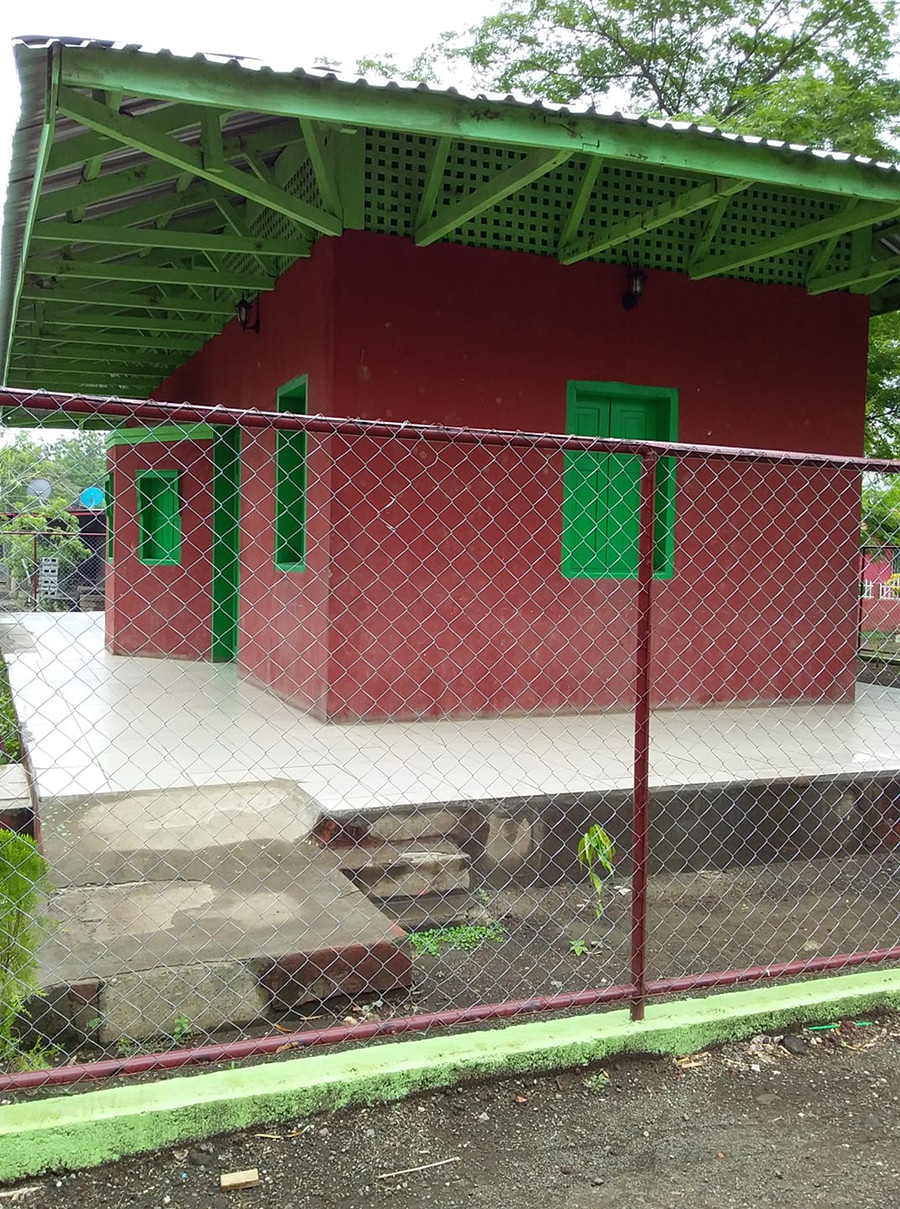
| Fotos tomadas durante; la restauración y reconstrucción de la estación "Los Brasiles" en un centro comunitario, el 30 de noviembre de 2016. | Photos taken during; restoration and rebuilding of the "Los Brasiles" station into a community center, on November 30, 2016. |
| Nota; En Las Siguientes ilustraciones; Los ojos con la flecha aproximan desde qué ángulo el fotógrafo tomó la foto. | Note; In the Following illustrations; The eyes with the arrow approximates from which angle the the photographer took the photo. |
Foto No.1 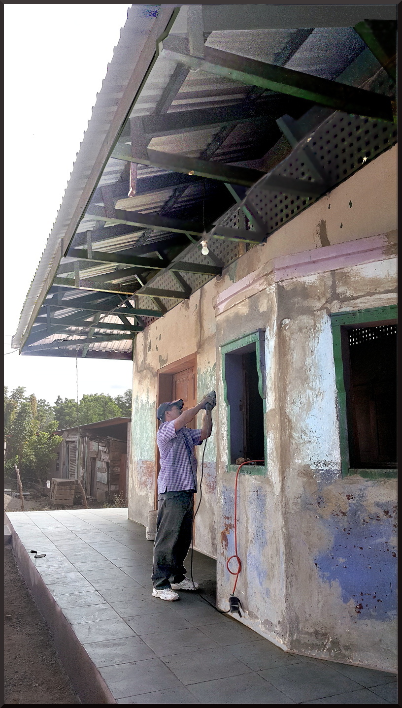 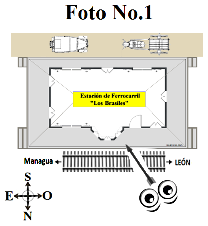 | |
| Mirando; la Ventana de Boletos (Lado de la Vía Férrea - Lado Norte) | Looking at; the ticket window (Train Track Side - North Side) |
Foto No.2 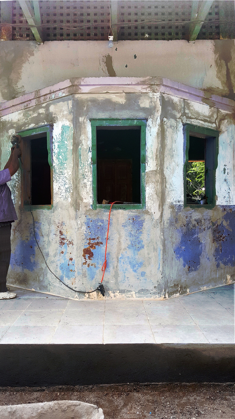 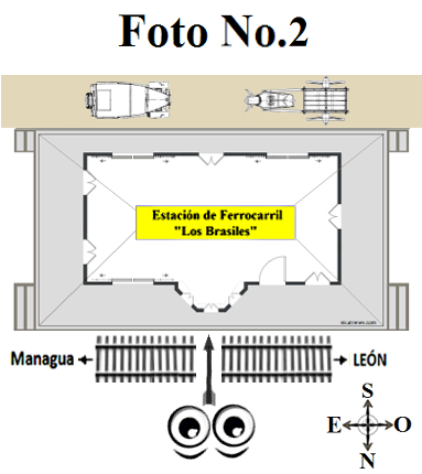 | |
| Mirando; la ventana de boletos (lado de la Vía Férrea - Lado Norte) | Looking at; the ticket window (Train Track Side - North Side) |
| Foto No.3 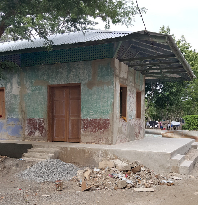  | |
| Mirando la estación de "Los Brasiles" desde el lado de la calle y el extremo Este del edificio. | Looking at "Los Brasiles" station from the Street Side and the East end of the building. |
Foto No.4 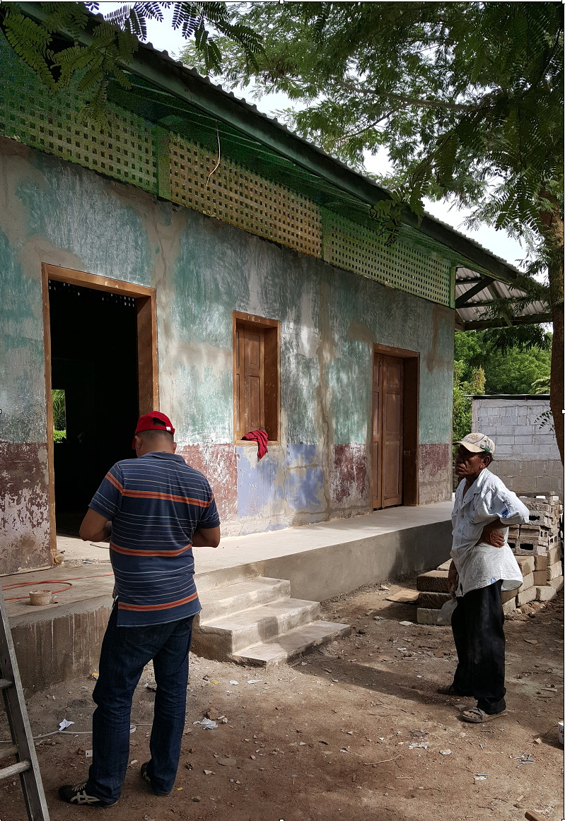 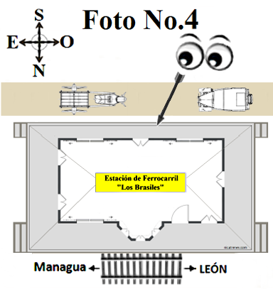 | |
| Mirando hacia; el lado de la calle (lado Sur) | Looking at; the Street Side (South Side) |
Foto No.5 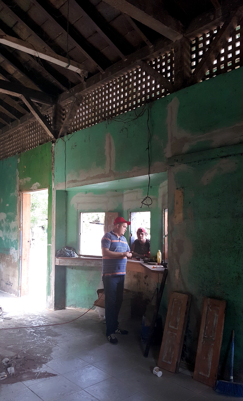 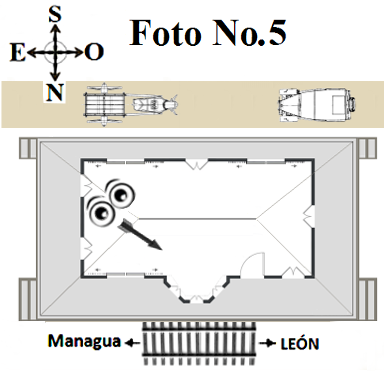 | |
| Interior; Mirando Ventana de Boletos | Interior; Looking at Ticket Window |
Foto No.6 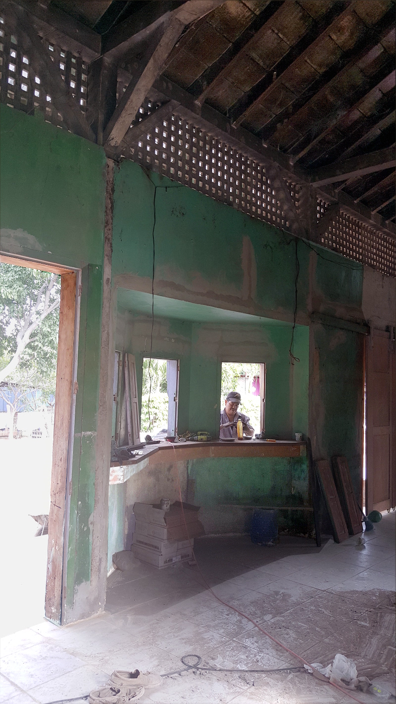 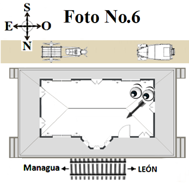 | |
| Interior; mirando a Ventana de Boletos | Interior; looking at Ticket Window |
Foto No.7 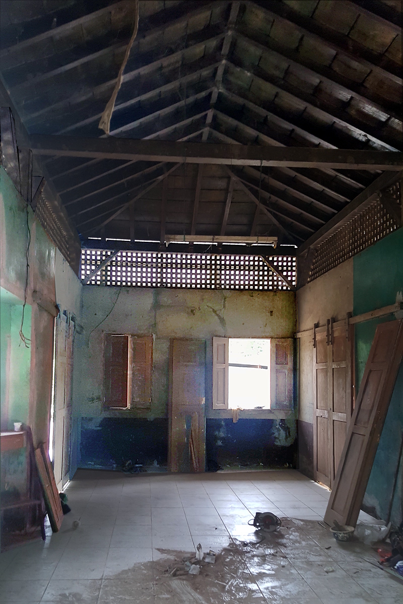 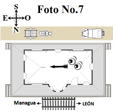 | |
| Interior; mirando al el lado Este que sólo tiene dos ventanas. Las puertas que se ven entre las ventanas sólo están apoyadas en la pared. | Interior; looking at East Side which only has two windows The doors seen in between the windows are only laying against the wall. |
Foto No.8 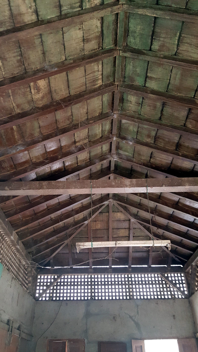  | |
| Interior; Techo = mirando al el lado Este | Interior; Roof = looking at East Side |
Foto No.9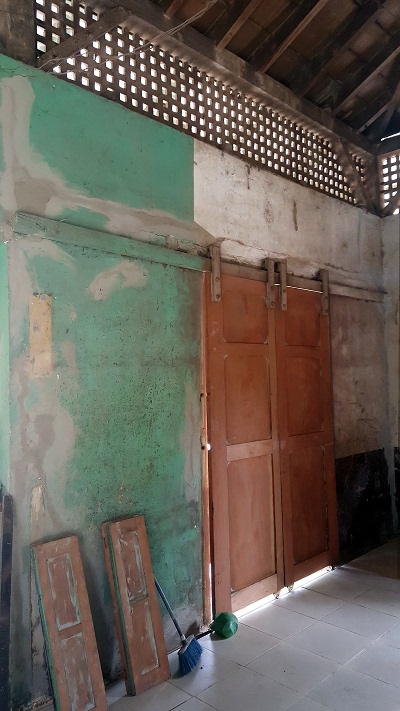  | Foto No.10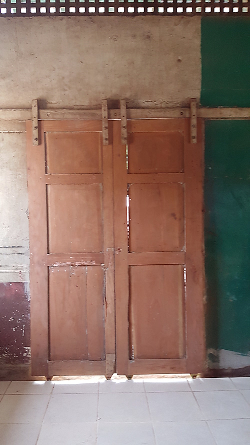 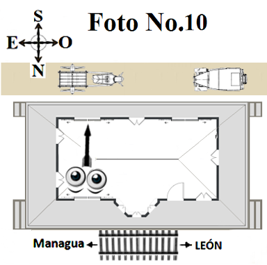 | ||
| Interior; Puertas corredizas - mirando hacia lado de la vía férrea. | Interior; Sliding doors - looking towards train Track side. | Interior; Puertas corredizas - mirando hacia al lado de la calle. | Interior; Sliding doors - looking towards Street side. |
Foto No.11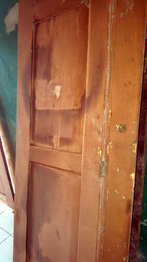 | Foto No.12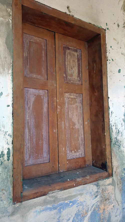 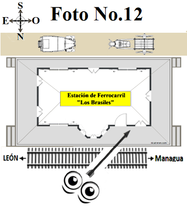 | ||
| Interior; Detalle de una puerta - posiblemente la puerta al Lado de la ventana de Boletos | Interior; Detail of a Door - Possibly the door on the side ticket window. | Exterior; Detalle de Ventana - Mirando hacia lado de la vía férrea. | Exterior; Detail of Window - looking at the train Track Side |
Foto No.13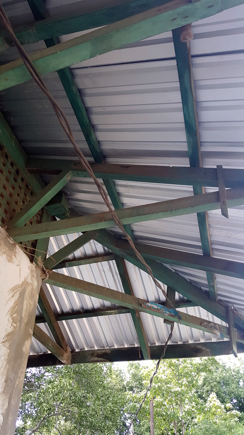 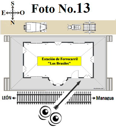 | Foto No.14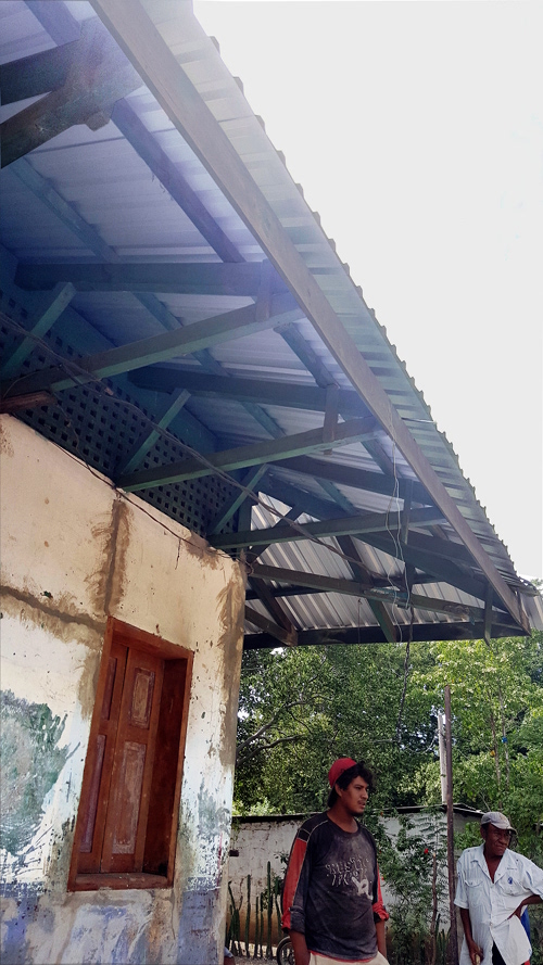 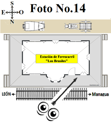 | ||
| Exterior; Detalle de Techo - Mirando hacia lado de la vía férrea - Lado de la ventana de Boletos. | Exterior; Detail of Roof - Train Track Side - ticket window side. | Exterior; Detalle de Techo y ventana - Mirando hacia lado de la vía férrea - Lado de la ventana de Boletos. | Exterior; Detail of Roof and window - Train Track Side - ticket window side. |
| El cambio de ruta que causó el traslado de la antigua estación "Los Brasiles." | The route change which caused the move of the old “Los Brasiles” station. | ||
Mapa con la antigua ruta del ferrocarril que pasa por la orilla de la Laguna de Asososca. 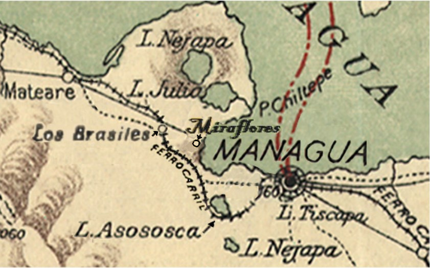 Map with the old Railroad Route passing by the border of the Lagoon of Asososca | |||
| Mapa con ruta Ferroviaria pasado por "Estación de Miraflores" a lo largo de las orillas de la costa del "Lago de Managua"("Lago Xolotlán") | Map with Railroad Route passing through "Miraflores Station" along the shores of "Lake Managua"("Lake Xolotlán") | ||
Vista de cerca / Close up view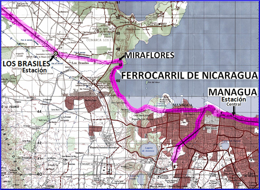 ======================== Vista panorámica / Panoramic view | |||
"Estación de Mateare" 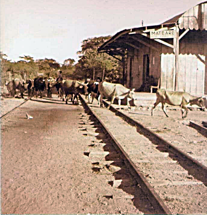 | |||
| "Estación de Mateare" Eduardo Grijalva dice; que en la estación de Mateare vendían torta fritas de pescado, hecas con sardinas. Mateare tenían criadero de sardinas. Primero secaban las sardinas tiernas, luego hacían la masa de tortilla con achote y la mezclaban con las sardinas tiernas, luego se freía, hacían las tortas del tamaño de una tortilla pero eran cuadradas. | "Estación de Mateare" Eduardo Grijalva says; that at the Mateare station they sold fried fish tortillas, made with sardines. Mateare had a fish-farm for sardines. First the baby sardines were dried, then they made the tortilla dough with achote and mixed it with the baby sardines, then it was fried, they made the tortias in the size of a tortilla but they were square. | ||
Mapa del ferrocarril desde la pared de la oficina del Ferrocarril de Nicaragua Este Mapa indica que la "Estación Los Brasiles" está en el kilómetro 123.43 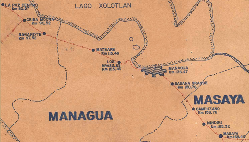 Map of railroad from the wall of the Nicaragua Railroad office This Map indicates; "Los Brasiles Station" to be at kilometer 123.43 | |||
| NOTA: Tres Referencias; con información del cambio de ruta que causó el traslado de la antigua estación de ferrocarril "Los Brasiles". / (1) Primero; Un informe de un documento oficial del "Ferrocarril del Pacífico de Nicaragua"; ***Cita de una carta al Gerente General (José de la Luz Guerrero), escrita por el Ingeniero de Mantenimiento del "Ferrocarril del Pacifico de Nicaragua" (Fecha 30 de julio de 1934): El Ingeniero de Mantenimiento escribe; CONSTRUCCION - Actualmente se está levantando la vía desde el K.109 sección 11ª (sección de "Boquerón") al K.116 ½ en la sección 12ª (sección de "Mateare") y desde el K128 al K.133 de las secciones 13ª (sección de "Los Brasiles") y 14ª (seccione de "Managua") en la parte que la via bordea el "Lago de Managua." (K.109 está en la - "Sección 11ª del Boquerón") (K.116 ½ está en la - "Sección de Mateare 12ª") (K128 está en la - "Sección 13ª de Los Brasiles") (K.133 está en la - "Sección 14ª de Managua ") (Esta información proviene de un documento oficial del "Ferrocarril del Pacifico de Nicaragua" en el "Archivo Histórico del Palacio Nacional de Nicaragua".) / nicatrenes agradece y aprecia al "Archivo Histórico del Palacio Nacional de Nicaragua" por compartir esta información con nuestra familia del ferrocarril de Nicaragua. | NOTE: There are three References; with information of the route change which caused the move of the old "Los Brasiles" railroad station. / (1) First; A report from an official document of the railroad, "Ferrocarril del Pacífico de Nicaragua"; ***Quote from a letter to the General Manager (José de la Luz Guerrero) written by the Maintenance Engineer of the "Ferrocarril del Pacifico de Nicaragua" (Date July 30, 1934): The Maintenance Engineer writes; CONSTRUCTION - The railroad track is currently being built from the Kilometer.109 of Section 11ª ("Boquerón Section") up-to the Kilometer.116 ½ in the Section 12ª ("Mateare Section"), and from Kilometer.128 to Kilometer.133 of the Sections 13ª and Section 14ª, sections where the railroad tracks borders "Lake Managua." ("Los Brasiles Section 13ª") y ("Managua Section 14ª") (K.109 is in the - "Boquerón Section 11ª") (K.116 ½ is in the - "Mateare Section 12ª") (K128 is in the - "Los Brasiles Section 13ª") (K.133 is in the - "Managua Section 14ª") (This information is from an official "Ferrocarril del Pacifico de Nicaragua" document in the the "Historical Archives of the Palacio Nacional de Nicaragua".) / nicatrenes thanks and greatly appreciates the "Historical Archives of the "National Palace of Nicaragua"; for sharing this information with our Nicaragua railroad family. | ||
Foto de la ruta ferroviaria de Nicaragua a lo largo de la laguna de Asososca. 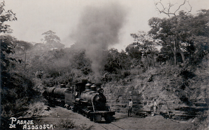 Passageway of Asososca (Photo of the Nicaragua railroad route along the Asososca Lagoon | |||
| (2) Desde el sitio web; Manfut.org Escribe un Autor para Manfut; "El invierno de 1932 fue tan copioso y sostenido las lluvias, que la crecida del "Lago de Managua" destruyó la vía férrea desde "El Boquerón" hasta "Los Brasiles." En esa ocasión se arrancó la vía, que pasaba por "Las Piedrecitas" y el bordé de la l"Laguna de Asososca", y se colocó donde ha permanecido hasta ahora , bastante próxima a la costa del "Lago de Managua", pasando por "Acahualinca" y los llamados -"Patios de Martínez." (NOTA; Todos los rieles fueron arrancados durante el cierre del "Ferrocarril de Nicaragua" en 1995.) (*2) manfut.org manfut.org/ managua/ tren.html En la Sección: "DESTRUCCION POR LAS FUERZAS DE LA NATURALEZA" | (2) From the website; Manfut.org An Author for Manfut writes; During the winter of 1932, the rains were so heavy and sustained it caused flooding from the high waters of "Lake Managua" which destroyed the railroad tracks from "El Boquerón" to "Los Brasiles." On that particular occasion the railrod tracks were torn-up, along the part of the route which passed by way of the park of "Las Piedrecitas" and along the edge of the "Lagoon of Asososca." The train route was moved to the location where they have remained until now, running quite close along the coast of "Lake Managua", passing through "Acahualinca" and the area known as "Patios de Martínez" (Pastures of Martínez.) (NOTE; All railroad tracks were torn-up during the closure of the "Ferrocarril de Nicaragua" in 1995.) (*2) manfut.org/ managua/ tren.html In the Section: "DESTRUCCION POR LAS FUERZAS DE LA NATURALEZA" (Translation; Distruction By The Forces Of Nature) | ||
Esta foto muestra cómo las vías férreas de Nicaragua quedaron en el aire, debido a la erosión de la tierra por las inundaciones. (Esta foto se utiliza como ejemplo); (Esta foto se presentó como retratada en un lugar de la zona de passocaballo.)  This photo shows how the Nicaragua railroad tracks were left in the air, due to the eroding of the ground from flooding. (This photo is used as an example); (This photo was presented as being taken at a location in the passocaballo area.) | |||
| (*3) Del Artículo; "Ocenta Anos Del Ferrocarril De Nicaragua" Autor; Minor Solís Jirón, Escribe el Autor Minor Solís Jirón; "El ferrocarril tuvo un deslave en la vía entre Mateare y Managua, las fuertes lluvias rompieron la tierra dejando los rieles en el aire por distintos puntos, no podían dejar la vía en ese mismo sitio. Traslado la vía, haciéndola pasara la orilla de la costa del lago de Managua, anos de 1932/33 (Esto fue durante la reconstrucción del terremoto que ocurrió en Managua en marzo de 1931). Trabajo que costo muchos millones de córdobas puesto que hubo que hacer cortes de grandes peñascos, dinamitándolas. Se quitaron los rieles que pasaban por el borde de la Laguna de Asososca acortándose la distancia en 3 kms. de la vía principal." (*3) Revista; "Banco Central" Boletín Nicaragüense de Bibliografía y Documentación No.27 Artículo: "Ocenta Anos Del Ferrocarril De Nicaragua" Autor; Minor Solís Jirón, Publicado; January -Febuary 1979 | (*3) From the Article; "Ocenta Anos Del Ferrocarril De Nicaragua" Author; Minor Solís Jirón, The Author Minor Solís Jirón writes; "The railroad had a wash-out along the line between Mateare and Managua, the heavy rains broke the ground leaving the rails in the air at different locations, they could not leave the railroad route in the same place. The track was rerouted, passing along the shores of lake Managua, in the years 1932/33 (This was during the reconstruction for the earthquake which occurred in Managua on March 1931). The work cost many millions of córdobas since it was necessary to make cuts of large rocks, by dynamiting them. The rails that passed along the edge of the Asososca Lagoon were removed, shortening the distance of the main line by 3 km. (*3) Book: "Banco Central" Article: "Ocenta Anos del Ferrocarril de Nicaragua" Author; Minor Solís Jirón, Boletín Nicaragüense de Bibliografía y Documentación No.27 Published; January -Febuary 1979 (Translation of the name of the Article; = Eighty Years of the Nicaragua Railroad) | ||
| Datos históricos interesantes sobre la ruta ferrocarril de Nicaragua desde "Mateare" hasta "Managua" | Interesting Historical facts consernining the railroad route from "Mateare" to "Managua" | ||
"Muelle de Momotombo"con el "Volcán Momotobo" al fondo. Fotógrafo; Hermeno Salvador año 1899 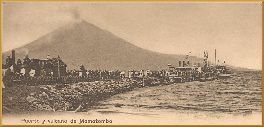 "Momotombo Pier" with the "Momotobo Volcano" in the bacground. Photographer; Hermeno Salvador year 1899 | |||
"Muelle de Managua" con locomotora y vagón de pasajeros 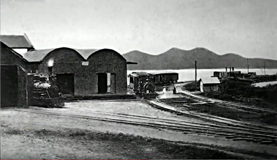 "Managua pier" with locomotive and passenger car | |||
| Datos históricos interesantes sobre la ruta ferrocarril de Nicaragua desde "Mateare" hasta "Managua"; Del Artículo "Ochenta Anos Del Ferrocarril De Nicaragua" del Autor; Minor Solís Jirón; Publicación; Enero -Febrero 1979 Boletín Nicaragüense de Bibliografía y Documentación No.27 Escribe el Autor Minor Solís Jirón; El ing. "Teodoro Hock" deterinaron que resultaba muy dificil extender la linea en el trayecto de Mateare a Managua". El Autor "Minor Solís Jirón" también dice que el plan original era ir en barco de vapor desde "leon Viejo' a través de un canal en "Rio Tipitapa" hasta Managua. ============= Tomado del Libro; “El Ferrocarril de Nicaragua - Historia y Liquidación” Autor; Orientar Bolívar Juárez (pub. 1997) ; Escribe el Autor Orientar Bolívar Juárez; Es intersante notar que en los planes original de constuir el nuvo ferrocarril de Nicaragua los estudios topograficos hecho por el ing. Teodoro Hock deterinaron que resultaba muy dificil extender la linea en el trayecto de Mateare a Managua por lo accidentado del terreno. Por esa razon, par hacer el viaje de Corinto a Granada se tenia que hacer el transbordo del ferrocarril a los vapores que surcaban el lago de Managua y de nuevo el ferrocarril hacia Granada. El presidente zelaya llevo a granada el famoso vapor victoria y decidio convertir a leon viejo en puerto momotombo. este puerto se construyo y quedo concluido en 1884. ================ Tomado del libro; Rails in Paradise Autor; Ross Escribe el Autor Ross; En 1924 las inundaciones cortaron la línea principal cerca de "Mateare". Entonces se construyó apresuradamente un muelle en el patio del ferrocarril en Managua, y durante 6 meses casi todo lo que viajaba entre "Mateare" y la ciudad capital de "Managua" fue manejado por barco. Lo mismo ocurrió en 1932. | Interesting Historical facts consernining the railroad route from "Mateare" to "Managua"; From the Article; "Ochenta Anos Del Ferrocarril De Nicaragua" (Translation name of Article = Eighty Years of the Nicaragua Railroad) Author; Minor Solís Jirón Published; January -Febuary 1979 Boletín Nicaragüense de Bibliografía y Documentación No.27 The Author Minor Solís Jirón writes; The engineer "Teodoro Hock" determined that it was very difficult to extend the line from Mateare to Managua. Author "Minor Solis Jiron" also says that the original plan was to go by steamboat from "Leon Viejo" through a canal on the "Rio Tipitapa" to "Managua." ================ Taken from the book; "El Ferrocarril de Nicaragua - Historia y Liquidación" (The Nicaraguan Railroad - History and Liquidation). Author; Orientar Bolívar Juárez (pub. 1997); The Author Orientar Bolívar Juárez writes; It is interesting to note that in the original plans to build the new Nicaraguan railroad, the topographical studies done by Eng. Teodoro Hock determined that it was very difficult to extend the line from Mateare to Managua because of the irregular terrain. For that reason, in order to make the trip from Corinto to Granada, it was necessary to transfer from the railroad (at "Puerto Momotombo") to a steam boat that crossed "lake Managua" and again pick-up the railroad at the capital city of "Managua" and take the train to "Granada." President "Zelaya" decided to convert "Leon Viejo" into a port called "Puerto Momotombo." This port was built and completed in 1884. ============== From the book; Rails in Paradise Author; Ross The Author The Author Ross writes; In 1924 floods cut the main line near "Mateare." A wharf was then hurriedly constructed at the railway yard in "Managua", and for 6 months nearly everything traveling between "Mateare" and the capital was handled by boat. Much the same occurred in 1932 to 1933. | ||
| Año 1932 | Year 1932 |
| Estación de Los Brasiles Inventario de la Bienes de la Estación | Los Brasiles Station Station Inventory of Property |
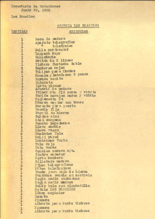 | |
| Estación de Los Brasiles Inventario de Articales Fecha del inventario; 30 de junio de 1932 / Del Libro: "Recapitulación del inventario de material a lo largo de la vía principal de junio de 1932", tomo.IX / Foto del documento original en: Los Archivos Históricos del "Palacio Nacional de Nicaragua" / nicatrenes agradece y aprecia enormemente al Archivo Histórico del "Palacio Nacional de Nicaragua" por compartir una copia de este documento con nuestra familia ferroviaria de Nicaragua. | Los Brasiles Station Inventory of Articales Date of inventory; June, 30 1932 / From the Book: "Ferrocarril Del Pacifico De Nicaragua" "Recapitulation of Inventory of Material Along Main Line as at June 30, 1932", tome.IX / Photo of the original document from: The Historic Archives of the "Palacio Nacional de Nicaragua" / nicatrenes thanks and greatly appreciates the "Historical Archives of the "National Palace of Nicaragua"; for sharing a copy of this document with our Nicaragua railroad family. |
| Año 1932 | Year 1932 |
| Inventario de los Bienes; De la Vieja Oficina y Vieja Bodega de Los Brasiles | Inventory of Property; Of the Old Office and Old Warehouse of Los Brasiles |
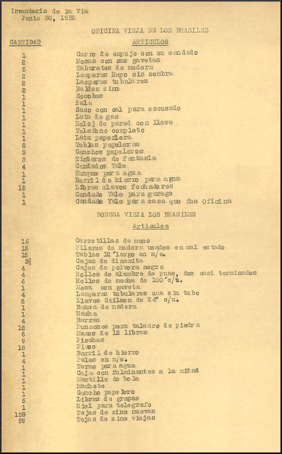 | |
| Inventario de Artículos del; Vieja Oficina y Vieja Bodega de Los Brasile Fecha del inventario; 30 de junio de 1932 / Del Libro: "Ferrocarril Del Pacifico De Nicaragua" "Recapitulación del inventario de material a lo largo de la vía principal de junio de 1932", tomo.IX / Foto del documento original de: Los Archivos Históricos del "Palacio Nacional de Nicaragua" / Escribe el autor para nicatrenes; Es interesante observar; en junio de 1932 la vieja estación y el bodega seguían en pie, no fueron destruidos por la inundación. El contenido del antiguo almacén/bodega incluía los artículos necesarios para realinear la ruta; cajas de dinamita, cajas de pólvora negra, y 6 rollos de mecha de 100 pies de largo cada uno, y brocas para cortar piedra (para hacer cortes de grandes peñascos, dinamitándolas.) (Cita de "Ocenta Anos Del Ferrocarril De Nicaragua" Autor Minor Solís Jirón escribe; "trabajo que costo muchos millones de córdobas puesto que hubo que hacer cortes de grandes peñascos, dinamitándolas." // 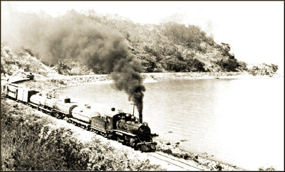 Nota; En esta foto vemos claramente la zona montañosa cercana a la orilla del lago (arriba a la derecha), y podemos entender por qué habría sido necesario utilizar la dinamita para hacer un espacio nivelado, para la vía del ferrocarril, a lo largo de la orilla del "Lago de Managua" entre la "Estación de Miraflores y la "Estación de Managua". / Flecha etiquetada con "Ferrocarril de Nicaragua" se aproxima al lugar donde se tomó la foto de la locomotora No. 28. / nicatrenes agradece y aprecia enormemente al "Archivo Histórico del "Palacio Nacional de Nicaragua" por compartir una copia de este documento ('Inventario de Articales de la "antigua oficina y antogua bodega de Los Brasiles") con nuestra familia ferroviaria de Nicaragua. | Inventory of Property for; Old Office and Old Warehouse of Los Brasiles Date of inventory; June, 30 1932 / From the Book: "Ferrocarril Del Pacifico De Nicaragua" "Recapitulation of Inventory of Material Along Main Line as of June 30, 1932", tome.IX / Photo of the original document from: The Historic Archives of the "Palacio Nacional de Nicaragua" / The author for nicatrenes wrote; It is interesting to note; in June of 1932 the old "Los Brasiles" Station and warehouse were still standing, they were not distroyed by the flooding. The contents of the old warehouse (bodega) included items necessary to realign the route; boxes of dynamite , also boxes of black powder, also 6 rolls of fuse 100 ft long each, and drill bits for cutting stone (to cut large boulders by dynamiting them.). (Quote from "Ocenta Anos Del Ferrocarril De Nicaragua" Author Minor Solís Jirón wrote; “The work cost many millions of córdobas since it was necessary to cut large boulders, by dynamiting them.” // Note; In this picture we clearly see the mountainous area close to the shore (upper right), and can get an understanding of why it would have been necessary to use the dynamite, to make a level space for the railroad route, along to the shore of "Lake Managua" between "Miraflores Station" and the "Managua Station". / Arrow tagged with "Ferrocarril de Nicaragua" approximates where photo below was taken of locomotive No. 28. / nicatrenes thanks and greatly appreciates "The Historic Archives of the "Palacio Nacional de Nicaragua" for sharing a copy of this the document ("Inventory of Articales from old office and old warehouse of the Los Brasiles") with our Nicaragua railroad family. |
| Año 1932 | Year 1932 |
| Sección de Mantenimiento #13 (Los Brasiles) Inventario de Articales | Maintenance Work Section #13 (Los Brasiles) Inventory of Property |
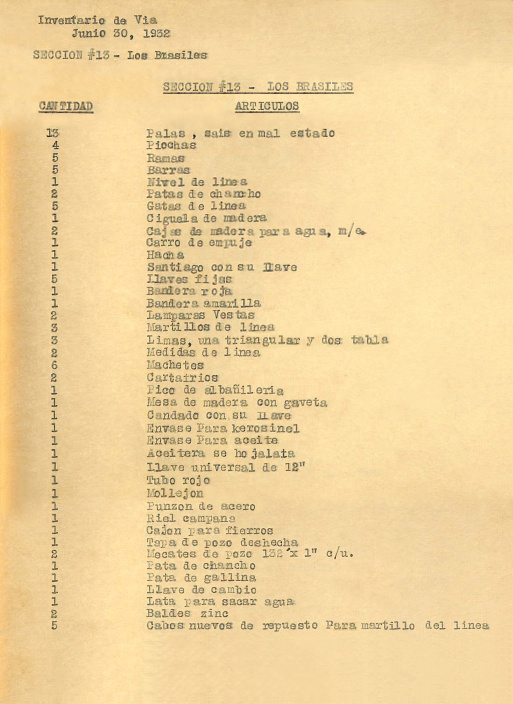 | |
| Sección de Mantenimiento Ferroviario #13 - "Los Brasiles" - Inventario de Articales. (Nota: "Sección de Mantenimiento13"; El mantenimiento de la zona de "Los Brasiles" desde el kilómetro 121 hasta el 132 era tarea de la "Sección de Mantenimiento 13") / Del Libro: "Ferrocarril Del Pacifico De Nicaragua "Recapitulación del inventario de material a lo largo de la vía principal de junio de 1932", tomo.IX Fecha del inventario; 30 de junio de 1932. / *Información sobre la Sección de Mantenimiento Ferroviario: Cita del Ingeniero de Mantenimiento del "Ferrocarril del Pacifico de Nicaragua" en el año 1934: SECCIONENES - La Empresa tiene dividido el sistema en secciones de mantenimiento de más o menos 10 kilómetros de vía cada una. En el kilómetro 110 termina la "Sección 11ª" ("Boqueron") y principia la "Sección12ª" ("Mateare"). En la "Sección 12ª"está el comienzo de la "División Oriental". (Nota: "Sección12ª" es la zona de Matere del 110 Km al 121 Km) Cada una de estas "Secciones" está a cargo de un capataz y 5 hombres, con excepción de la "Sección 14ª" (Managua) que tiene 7 hombres. (Nota: "Sección 14ª" es la zona de Managua del 132Km al 141.9Km) / Foto del documento original de: Los Archivos Históricos del "Palacio Nacional de Nicaragua" / nicatrenes agradece y aprecia enormemente el Archivo Histórico del "Palacio Nacional de Nicaragua" por compartir con nuestra familia ferroviaria nicaragüense; una copia de este documento original del Inventario de Articales de la "Sección de Mantenimiento Ferroviario #13ª" de Los Brasiles. | Railroad Maintenance Section #13 - "Los Brasiles" - Inventory of Property. (Note: Maintenance Section #13; It was the job of "Maintenance Section 13" to maintain the Los Brasiles area from 121 Km to 132 Km) / From the Book: "Ferrocarril Del Pacifico De Nicaragua" "Recapitulation of Inventory of Material Along Main Line as at June 30, 1932", tome.IX Date of inventory; June, 30 1932. / *Information about Railroad Work Section: Quote from the Maintenance Engineer of the "Ferrocarril del Pacifico de Nicaragua" from the year 1934: SECTIONS - The Company has divided the system into maintenance sections of about 10 kilometers of track each. At kilometer 110, Section 11" (Boqueron) ends and section 12(Mateare) begins. At the 12th section (110 Km) is the beginning of the "División Oriental" ("Eastern Division"). (Note: Section 12 = Mateare = 110 Km to 121 Km). Each of these sections is run by a foreman and 5 men, with the exception of section 14 (Managua) which has 7 men. (Note: Section 14 = Managua = 132 Km to 141.9 Km). / Photo of the original document from: The Historic Archives of the "Palacio Nacional de Nicaragua" / nicatrenes thanks and greatly appreciates The Historic Archives of the "Palacio Nacional de Nicaragua" for sharing with our Nicaragua railroad family; a copy of this original document of the Inventory of Articales of the "Railroad Maintenance Section #13" of Los Brasiles. |
| ||||||||||||||||||||||||||||||||||||||||||||||||||||||||||||||||||